
In 1.252J Urban Transportation Planning, Frederick Salvucci organizes walking tours featuring aspects of Boston’s transportation history and local transportation issues. These walking tours are often highlights of the course for students. In this section, he shares some of the locations he visits with students and offers advice to educators planning walking tours of their own.
Cambridge and the Inner Belt
We begin by walking near Central Square in Cambridge, in an area that was supposed to be torn down in the 1960s to build the Inner Belt (Interstate 695). The community protested and the highway was never constructed. On the walk, I explain to students how the plan did not make any sense from a socioeconomic point of view. We also talk about how it made no sense from a traffic point of view, which is kind of shocking, because it was supposed to be a transportation facility. The walking tour enables students to see the result of blocking the highway from being built: a neighborhood that still thrives today.
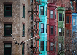
A block from the South End of Boston. (Courtesy of Greg Lyons on Flickr. License: CC BY.)
The South End and the Orange Line
Then, we take the bus to the Massachusetts Avenue Station and the MBTA Orange Line, where the Southeast Expressway extension was supposed to blast through the South End of Boston. Just as with the Central Square stop, we do this to see the kind of neighborhood that was threatened. I explain that we were able to block the extension, and at the same time, were able to secure an equal amount of money for public transit. Students observe, first hand, the benefits of spending the money on the building of the Orange Line and the public park over the line between Massachusetts Avenue and Back Bay Station.
The Big Dig
Depending on the weather, we usually walk around Copley Place in Back Bay, and sometimes get on the subway and go to North Station. We look at how North Station has evolved. We might look at a block of the Rose Fitzgerald Kennedy Greenway, which grew out of the Big Dig. We also might go see the stone that marks the center of Boston, just off of Hanover Street, before taking the subway back to MIT.
We usually walk that route, unless it’s raining, in which case I have a covered route that focuses more on the inside of the subway system, such as Park Street Station and North Station. So there’s a good weather route and a bad weather route, each offering different perspectives on similar topics: the neighborhood that would have been destroyed by the Inner Belt, the way money was spent in the South End on the Orange Line — and a little piece of the Big Dig.
Advice for Educators Planning Walking Tours
"The idea is to get students to see different things."
If you are going to design a walking tour for a similar course, I would recommend selecting sites that you know yourself from your own experience, or that you’ve learned about, so you can point things out that your students wouldn’t notice or understand if they walked by themselves. The idea is to get students to see different things. Also, pick a nice day, if you can, because part of the fun is being outside, looking at, and enjoying, the city.


