
12-453f05.jpg
Description:
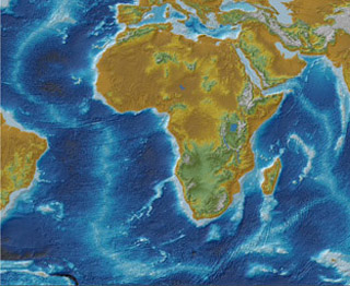
Topographic relief of the African plate. The data sources: NASA SRTM (land topography), and D. Sandwell (ocean bathymetry). (Image courtesy of Daniel MacPhee.)
file
79 kB
12-453f05.jpg
Alt text:
Topographic relief of the African plate. Areas of higher elevation are represented in light blue.
Caption:
Topographic relief of the African plate. The data sources: NASA SRTM (land topography), and D. Sandwell (ocean bathymetry). (Image courtesy of Daniel MacPhee.)
Course Info
Instructor
Departments
As Taught In
Fall
2005
Level
Learning Resource Types
notes
Lecture Notes


