
12-804f09.gif
Description:
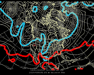
Animated tropopause maps at 12 hour intervals during the Blizzard of 2003, a typical “northeaster” with record breaking snowfall for Boston. Tropopause maps such as these are an analysis of potential temperature (color contours) on a surface of constant potential vorticity, Q (Q = 2.0 PVU). This analysis contains the essential information needed to understand the dynamics of weather systems within the troposphere. “Cold” tropopause (i.e. low potential temperature) regions are associated with cyclonic circulations, while “warm” tropopause regions are associated with anti-cyclonic circulations. (Image by Dr. Lodovica Illari.)
file
83 kB
12-804f09.gif
Alt text:
Blizzard of 2003 tropopause analysis.
Caption:
Animated tropopause maps at 12 hour intervals during the Blizzard of 2003, a typical “northeaster” with record breaking snowfall for Boston. Tropopause maps such as these are an analysis of potential temperature (color contours) on a surface of constant potential vorticity, Q (Q = 2.0 PVU). This analysis contains the essential information needed to understand the dynamics of weather systems within the troposphere. “Cold” tropopause (i.e. low potential temperature) regions are associated with cyclonic circulations, while “warm” tropopause regions are associated with anti-cyclonic circulations. (Image by Dr. Lodovica Illari.)
Course Info
Instructors
Departments
As Taught In
Fall
2009
Level
Topics
Learning Resource Types
group_work
Projects


