chp_chaco_roads.jpg
Description:
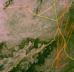
Around Chaco Canyon, New Mexico, NASA’s Thermal Infrared Multispectral Scanner (TIMS) detected over 200 miles of a prehistoric roadway system (shown in red, fanning out from lower right). Compare these prehistoric roads with the current day roads, in yellow, which follow the topography and path of least resistance in construction. Why were the Chacoan roads designed with exacting linearity, surmounting any topographic obstruction, built to a width of 20 feet or more, and constructed by people who did not even employ beast of burden in their lives? (Image courtesy of NASA.)
file
29 kB
chp_chaco_roads.jpg

Course Info
Instructor
Departments
As Taught In
Fall
2006
Level
Topics
Learning Resource Types
assignment
Written Assignments


