2 - Foundation of al-Fustat
1006.jpeg
Description:
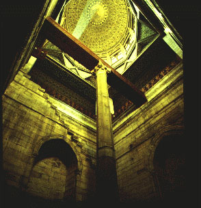
View of the shaft of the Nilometer at Rawda Island. A water intake built 716, and rebuilt 861, was used to measure the annual flood level in order to assess the taxes to be levied on crops. It consists of a graded marble column in the middle of a well connected to the Nile through tunnels dug on three levels topped by a light conical dome. The walls of the well are decorated with beautifully carved Kufic Qur’anic inscriptions referring to water, prosperity, and vegetation, and therefore playing an iconographic role in this crucial structure for the understanding of the economic and social history of Egypt.
file
63 kB
1006.jpeg
Alt text:
View of the shaft of the Nilometer at Rawda Island
Caption:
View of the shaft of the Nilometer at Rawda Island. A water intake built 716, and rebuilt 861, was used to measure the annual flood level in order to assess the taxes to be levied on crops. It consists of a graded marble column in the middle of a well connected to the Nile through tunnels dug on three levels topped by a light conical dome. The walls of the well are decorated with beautifully carved Kufic Qur’anic inscriptions referring to water, prosperity, and vegetation, and therefore playing an iconographic role in this crucial structure for the understanding of the economic and social history of Egypt.

Course Info
Instructor
Departments
As Taught In
Spring
2002
Level
Topics
Learning Resource Types
collections
Image Gallery


