
Course Description
This graduate level course presents theories, methodologies, and applications of seismic imaging for solving the shallow near-surface (0 - 500 m) effects on the seismic data processing for oil and gas exploration on land. It introduces both conventional and advanced imaging technologies that have been developed in …
This graduate level course presents theories, methodologies, and applications of seismic imaging for solving the shallow near-surface (0 - 500 m) effects on the seismic data processing for oil and gas exploration on land. It introduces both conventional and advanced imaging technologies that have been developed in academia and the seismic industry.
Course Info
Instructor
Departments
Learning Resource Types
notes
Lecture Notes
grading
Projects with Examples
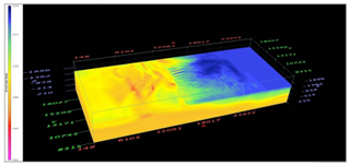
3D near-surface seismic velocity model of Xinjiang, China, derived from the first-arrival traveltime tomography. (Image by Prof. Jie Zhang.)


