
Course Description
Learn how to read and interpret maps and data and use basic cartography principles to create maps that can be used in reports and presentations. After learning basic concepts, attendees will work through an exercise using ArcGIS Pro or QGIS.
Course Info
Instructor
Topics
Learning Resource Types
assignment
Activity Assignments
edit_note
Editable Files
Instructor Insights
notes
Lecture Notes
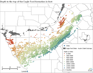
Students learn to use two programs to generate maps. (Courtesy of U.S. Energy Information Administration. Image is in the public domain.)


