Based on MIT S.M. thesis by Raymond K. S. Ty (1987).
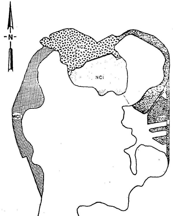
Boston Peninsula
Surface area initally < 500 acres, only narrow neck (today’s Washington St.) was the connection to the mainland, in several locations along the shore there were marshes, several hills served as filling material
|
West Cove: |
Filling began 1804 with material from Mt. Vernon à today’s Charles St. (WC1) |
|
North Cove: |
1640 construction of a mill dam/causeway across cove, creating a pond |
|
1805 filling of mill pond with material from Beacon hill + rubbish (NC1 and NC2) |
|
|
East Cove: |
1673: Old Wharfe (wall of wood and granite blocks) |
|
18th century: several timber wharves, 1st half of 19th century new generation of wharves with granite walls + fill placed between old and new wharves |
|
|
1870: Atlantic Ave. is filled at about location of Old Wharfe |
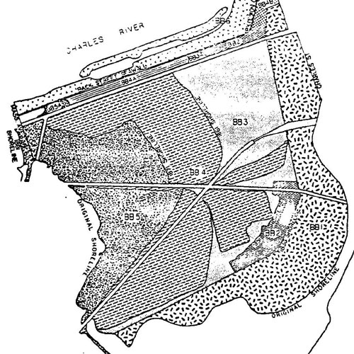
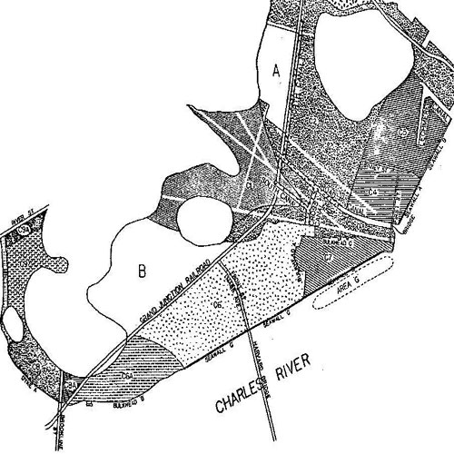
Back Bay
Area between Charles River (N), Charles St. (E), original shoreline (S) and Mass Ave (W)
Before it was filled it was a large area of marshy flats with channels for river flow. Filling began in early 19th century with peak activity at the end of 19th century. The last phase was the constitution Storrow Drive in 1930
- 1820: construction of Mill Dam and Cross Dam creating two basins
- by 1835 two railroads crossed the flats
- for many years the sewage of Boston was drained into the basin
- 1805: start of filling with city ashes and other refuse (BB1), 1830-1850 small fills (BB2)
- 1860-1880: major filling: area from Arlington St. to Mass Ave. (BB3 - BB5), concurrently a seawall was built along the Charles River and backfilled with river material and sand/gravel from Needham, creating Back St. (BB3A - BB5A)
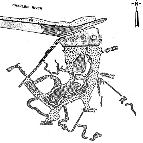
Back Bay Fens
- 300 acres west of Back Bay originally marshes an winding rivers, known as Full Basin after construction of Mill Dam and Cross Dam
- Most of the filling started in late 1870’s as a continuation of the filling of Back Bay and continued for about 10 years.
- Along the Charles River construction of seawalls and backfilling (F1 - F3). Dredging resulted in the removal of unsightly flats in front of the seawall and in the deepening of Charles river for navigation.
- Together with the construction of Back Bay Park, covered channels for Stony Brook and Muddy River were built. The original rivers were filled with gravel.
Cambridge and Allston
Originally there was a broad floodplain of the river with salty marshes, springs, ponds and quiet streams. First changes occurred in the 18th century through construction of bridges and connecting roads. Originally there were three islands: Lechmere’s Point, Pelham’s Island and Captain’s Island. All of them disappeared during filling operations.
- Pelham’s Island and Lechmere’s Point were connected to Cambridge and Boston through embankment roads and bridges.
- Bridges between Cambridge and Boston were: West Boston Bridge (Longfellow Br.) 1793, Canal/Craigie Bridge (Charles River Dam) 1807.
- A railroad embankment across the river marshes of Cambridge kept the tidal water from the area in its back.
- 1st half of 18th century: filling of marshes between Lechmere’s Point, Pelham’s Island and mainland (C1+2)
- 1870’s: filling of area around Miller’s River (East Cambridge) (C3)
- 1892: construction of seawalls from Broad Canal to Binney St. and backfilling, prolongation of seawalls in 1895 (C4 + C5)
- 1883 - 1904: construction of granite seawalls along the Charles and subsequently filling of area between railroad embankment, Main St. and seawalls (C6, C6A, C7)
- 1890: finishing of Harvard Bridge. Was first without connection on Cambridge side because filling operations there made only slow progress.
- 1899: construction of dam between Brookline St. and Captain’s Island and filling of the area with gravel à served as playground and bathing beach (C8, C8A)
- 1901 - 1911: filling of flats north of Captain’s Island + south of River St (C9, C9A, C9B)
- 1898 - 1902: filling on south side of Charles River between Boylston St. and Arsenal St. bridge (C10)
- City dump site in North Cambridge (C11): refuse dumping between 1946 and 1971
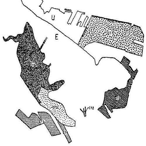
Charlestown
Charlestown was originally a triangular peninsula, connected to the mainland through a neck at the NW-part of the town. It was once the junction of the Charles, Miller’s and Mystic River. Connections to Boston with Charles River Br. (1786), Warren Br. (1828) and later Prison Point Bridge
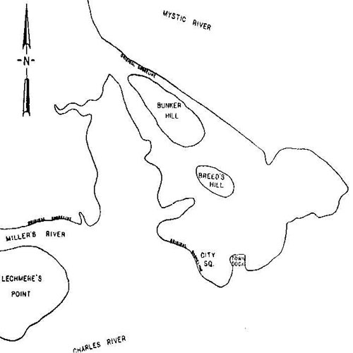
- 1840 - 1880: foundation of navy yard and continuing filling operations (CT1)
- In the East there was a protected deepwater cove (Town Dock) which was important for trade and shipping. Later a bridge obstructed the dock and 1835 a fire destroyed most of it à the area was filled (partially with rubble from the fire) (CT2)
- 1840: filling of additional land behind seawalls with material from Bunker Hill (CT3 + 4)
- 1880: area of Prison Point Bridge is filled (CT5)
- The original west shoreline ran approx. along today’s Main St. with large flats adjacent to it. In early 18th century there was a Mill Dam enclosing a pond which was filled in 1880 (CT6)
- Mystic Wharf was built in 1890 to the north of the Charlestown peninsula (CT7)