res-env-001iap17.jpg
Description:
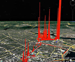
The class drove through some urban streets in a van equipped with a GPS-linked methane analyzer. The height of the red spikes are proportional to measured methane concentrations. Lower left is near the MIT campus, with the so-called “Alps of Somerville” to the upper right. Image courtesy of Audrey Schulman / HEET.
file
35 kB
res-env-001iap17.jpg
Alt text:
Map image with red line showing the path of van, and some very high vertical spikes.
Caption:
Participants in this class drove through some urban streets in a van equipped with a GPS-linked methane analyzer, producing data and visualizations like this. The height of the red spikes are proportional to measured methane concentrations. Lower left is near the MIT campus, with the so-called “Alps of Somerville” to the upper right. (Image courtesy of Audrey Schulman / HEET.)
Credit:
Image courtesy of Audrey Schulman / HEET.

Course Info
Instructors
As Taught In
January IAP
2017
Level
Topics
Learning Resource Types
collections
Image Gallery
theaters
Lecture Videos
theaters
Workshop Videos
theaters
Video Materials
notes
Lecture Notes


